Sign Up For Our eNewsletter
Get the latest news, happenings & more from the Chelan-Douglas Land Trust.


Article in partnership with The Wenatchee World
by Bob Bugert
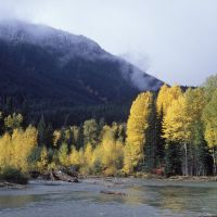
The Chelan-Douglas Land Trust (CDLT) has a strong track record of protecting important salmon habitat in such regional rivers and streams as the Entiat River, Icicle Creek, Nason Creek, and lower Wenatchee River. More than any other local waterway, however, CDLT has received grants from county, state, federal and private entities to protect the salmon habitat and flood plains of the White River. To date, the organization has protected 8.6 miles of the river’s shorelines, which along with the holdings of the Forest Service and the Washington Department of Fish and Wildlife, has kept the entire 33 miles of the river in a relatively natural state.
Why the focus on the White River? From a salmon standpoint, it is the most productive river in Central Washington because it still has a healthy floodplain free of human channelization. This natural functioning floodplain, among many other things, provides salmon with the late-season flow of water and the necessary silts and gravels to spawn. It also provides early-season habitat supporting juvenile salmon.
The beauty of a floodplain that supports salmon, is just how much else it supports. It sustains the diverse microbiology, plant life, and insect life forming the foundation of a food chain allowing hundreds of species of birds, reptiles, and mammals to thrive.
People also benefit from the recreational, aesthetic, spiritual or economic offerings of pristine watercourses. We often overlook the economic offering, but the economic benefits of healthy floodplains are significant. Floodplains slow down water during floods, allowing it to disperse across adjacent low-lying lands so that the water can gradually infiltrate the soil. By slowing down and temporarily retaining water during floods, floodplains protect downstream homes and communities from damage. Much of that retained water, meanwhile, seeps downward and becomes stored as groundwater. This groundwater percolates downhill and will eventually reappear as surface water downstream, typically in late-summer months when water supply to downstream users (cities, homes, and farmers) is limited. Also, when water seeps into the ground, the process of infiltration cleans and cools the waters, which benefits all of us.
For these reasons, floodplain protection is a tool used by many municipalities to provide a reliable source of clean water to its users. Walla Walla is a nearby city investing in this kind of water treatment. And with eight million users, New York City is a distant example. Both cities use watershed/floodplain protection to, cost-effectively, deliver clean water to their residents.
A fun way to contemplate all of this is to visit the White River in autumn. Sockeye salmon can be seen spawning from mid-September to mid-October in the redds (depressions) females excavate in the river gravels of slower moving water. Each female forms a few redds and deposits several hundred eggs in each, which the males will fertilize.
Juvenile sockeye emerge from the gravels of these redds in spring and slowly make their way downstream. The side channels of the floodplains provide important hiding and feeding cover for the young sockeye before they move into Lake Wenatchee. Once in the lake, the young sockeye spend a year or two growing before migrating downstream to the ocean. Here they spend an average of two years feeding before starting the long journey back to their natal stream to spawn. This cycle of salmon has repeated itself long before humans inhabited the region, but by providing conditions that benefit that cycle we benefit our own habitation here.
Trip Details –
Experience the natural beauty and the bountiful wildlife of the White River with a salmon-viewing outing. This can be done solely by automobile, but bicycling part of the route below is worthwhile.
Access. Drive Highway 2 west of Leavenworth 14 miles to Cole’s Corner and turn right onto Highway 207. Follow Highway 207 (which turns in the Lake Wenatchee Highway after 4.3 miles) for a total of 10.5 miles to the White River Road. Turn right onto the White River Road and zero out the odometer. Drive 6.2 miles on the White River Road to the Twin Lakes Trailhead and park. The trailhead signage is somewhat hidden and easily missed –if you reach a single-lane bridge crossing the Napeequa River, you’ve gone a few hundred yards too far.
Salmon Pools. From the Twin Lakes Trailhead, walk downriver along the road for 100 yards to a pullout on the right with a barricade discouraging parking because of ‘hazard trees.’ At this pullout, find the very short trail leading down to a gravel bar bordering the river. The pool on the upriver side of the gravel bar is filled with hundreds of sockeye and many redds from mid-September to mid-October. Take a seat and enjoy the spectacle.
Important. Please don’t disturb the fish by walking in the river or pacing continually along the riverbank. The fish are disturbed easily and are in a weakened state from their long return journey back to this spawning pool.
Biking. Rather than driving the 6.2 miles along the White River Road, consider biking this quiet portion of road (all paved). Park in the triangle of land between the White River Road and Lake Wenatchee Highway. If you want to bike the entire length of the White River Road – a total of 10.2 miles (one way) – be aware that the final 3.8 miles of the road is not paved and best suited for mountain bikes.
Hiking. Given that you’ll be seeing the Twin Lakes Trailhead, you might consider hiking to the lakes. It's a forested 3-mile (one-way) hike to the first lake, 3.5 miles (one-way) to the cabin between the two lakes. See the WenatcheeOutdoors ‘Hiking’ guidebook for details.
Permits. A Northwest Forest Pass (or federal-pass equivalent) is required to park at the Twin Lakes Trailhead.
Land Designation. The riverbanks are a combination of lands owned by the Chelan-Douglas Land Trust (CDLT), Washington Department of Fish and Wildlife, U.S. Forest Service, and private citizens.
Upcoming Events. Join Chelan Douglas Land Trust and Columbia Valley Community Health for the final Hike for Health on Saturday, October 11, at Saddle Rock Natural Area from 10:00 am to 12:00 pm. Enjoy a community walk, then stay for free food, music, family activities, and a raffle offering the chance to win outdoor-related prizes. Learn more at cdlandtrust.org/events.
Bob Bugert is a retired fisheries biologist, was the Executive Director of the Chelan-Douglas Land Trust for ten years, and served one term as a Chelan County Commissioner. Join him in supporting CDLT’s many projects that enhance our regional quality of life. (https://www.cdlandtrust.org/support-us/membership)
Forty for Forty. Recognizing the 40th Anniversary of the Chelan-Douglas Land Trust with 40 stories about places the CDLT has protected and kept open for public access.
Online Resource

Trail maps, directions, more info

40 Years of Conservation Success
