Sign Up For Our eNewsletter
Get the latest news, happenings & more from the Chelan-Douglas Land Trust.
![]()

Forty for Forty: The One-Two Divide
by Andy Dappen
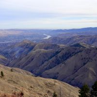
When someone mentions hiking the One-Two Divide, my eyes turn rosy — I count it among my favorite walks in the foothills. The same mention makes my wife’s eyes turn red — she finds it an unpleasant affair.
For me, I enjoy the steep, slippery, heart-pumping push up Chopper that gets you up on the divide fast with none of the dilly-dallying of modern trails taking eons to climb a slope. And once atop Chopper, the crest of the divide heading west undulates up and down and winds north and south. I love following the game trails that come and go; love walking toward Twin Peaks feeling like I’m in a completely wild domain then turning around to see Wenatchee at my feet; and love the notion that from Castle Rock I can hike from front country to backcountry and from backcountry to places farther than I can walk. I call this a gateway from near to infinity.
For my wife, she dislikes the steepness, looseness, and insecurity of the ‘trail’ heading up Chopper. She dislikes the uncertainty of the game trails that may or may not take her where she wishes to go; dislikes the lack of signage giving her the occasional confirmation that she’s on track; and dislikes the thought that a misstep might send her tumbling into hidden nooks where her bones might never be found.
I often recommend this walk to experienced hikers, “You’ll love it,” I effuse. My wife tells a tale of a very different city. See for yourself what you think.
Details. Hiking the One-Two Divide.
For experienced hikers, this walk following the high divide between Number One and Number Two canyons is a gateway into the wild. From the divide (and with enough time) you could travel to Blewett Pass, into the Alpine Lakes Wilderness, and to the Pacific Crest Trail. Turn left on the PCT and go to Mexico, or turn right if you’d prefer visiting Canada. That being said, be aware that the gateway to all of this is through the Chelan-Douglas Land Trust’s Castle Rock Ridge property and via the unimproved, eroded, and very slippery social trail up Chopper, the far larger peak that is immediately west of Castle Rock. The Land Trust has signage at the base of this spur discouraging its use. I write this story partly in an effort to encourage the organization to build a good trail up Chopper. This should not be a wandering trail that scars the entire face of the peak with a zig zagging tread, but a direct trail using well-designed steps that eliminate erosion yet reach the divide quickly.
Access. From the intersection of Western Avenue and Castlerock Avenue in Wenatchee, head west (uphill) on Castlerock Avenue for 0.3 miles and park at road’s end. There is a picnic structure and vault toilet at the trailhead. NOTE: If all the designated parking stalls are occupied, drive back down the hill 50 to 100 yards and street park – don’t clog up the circular turn-around by parking beside the ‘No Parking’ signs.
Trip Instructions. From the trailhead, use the maps on the property to reach the saddle between Chopper and Castle Rock (1 mile). Climb directly up the steep, loose trail to the top of Chopper (0.5 mile). Now follow the game trails on top of the divide that head west into the hills. Occasionally a rock outcrop will block the crest of the ridge and you’ll need to cut below the obstacle on either the north or south side of the crest. After following the divide for about 4 miles, reach peaklet 3,761’ (the end of the divide). Walk in a southwesterly direction off this peaklet and you’ll quickly intersect a trail. Follow the trail downhill until reaching the new parking lot for the different Twin Peak trails. This route entails a moderate amount of navigation — carry a good topographic map and know how to use it.
Trip Stats. Hiking from the trailhead up and along the divide until it intersects the south ridge of Twin Peaks at peaklet 3,761’ is roughly 5.5 miles long and gains about 2,800 vertical feet. Following the trail down to the new, parking lot for the Twin Peaks trails is another 2 miles of downhill walking.
Shuttle Options. The shortest, quickest way to do this trip is to leave a shuttle vehicle at the new, upper parking lot on Twin Peaks. I prefer driving with my mountain bike to this trailhead, leaving the car here, and riding the bike back to the Castle Rock Trailhead (about 6 miles, downhill). Trail runners can make things simpler still and simply run back to the start.
Allowed: Hiking and trail running. Dogs must be leashed on the first several miles of the route while on City and Land Trust property.
Not Allowed: On the City and Land Trust portions of this hike (the first several miles), motorized vehicles, horses, off-trail travel, picking of plants, hunting, shooting, nighttime use, campfires, and littering are all prohibited.
Land Ownership. The Castle Rock Natural Area abutting the parking area was acquired by the Chelan-Douglas Land Trust in 2013. The property was later deeded to the City of Wenatchee, but the Land Trust maintains the trails and holds a conservation easement to the property that prevents future development. The higher lands protecting Castle Rock proper and Chopper as natural areas were acquired by the Land Trust in 2023 and are referred to as Castle Rock Ridge. This property connects to BLM land to the west, which in turn connects to USFS land.
Upcoming Events. Celebrate the Winter Solstice with a sunrise hike at Castle Rock on Saturday, December 20, from 7:00–9:00 a.m. Join the Chelan-Douglas Land Trust to welcome the shortest day of the year and connect with others on the trail. Register at cdlandtrust.com/events
Andy Dappen is a former board member of the Chelan Douglas Land Trust.
Forty for Forty. Recognizing the 40th Anniversary of the Chelan-Douglas Land Trust with 40 stories about places the CDLT has protected and kept open for public access.
Online Resource

Trail maps, directions, more info

40 Years of Conservation Success
