Sign Up For Our eNewsletter
Get the latest news, happenings & more from the Chelan-Douglas Land Trust.


Article in partnership with The Wenatchee World
Forty for Forty: Dry Gulch
I first developed my love for trail running on the winding trails of Dry Gulch. This shrub-steppe open space, abutting the southwest border of Wenatchee, offers immediate access to trails for hiking, horseback riding and … running. Within five minutes of leaving my house, I discovered I could find myself on a trail listening to the early morning yips of a coyote, hearing the thunderous fluttering of sage grouse bursting into flight, or watching bald eagles soaring next to me as I moved along the ridge line.
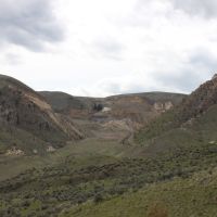
Previously the site of the second largest gold mining operation in the United States until 1994, this 700-acre parcel of land was obtained in 2007 by Appleatchee Riders. The riding club created a limited partnership, called the Dry Gulch Preserve LLC, which holds and manages the property. The Chelan-Douglas Land Trust, meanwhile, holds a conservation easement to the property, ensuring that the area will not be developed in the future. Ensuring the property would not be developed was a stipulation of the 2007 transfer of the property because buried heavy metals that were byproducts of the area’s mining history would be disturbed and dispersed by development.
As a family practice doctor specializing in weight management and helping patients establish healthy lifestyles, I have seen the benefits of regular exercise for improving and maintaining health. Roughly 30 minutes of medium-intensity exercise (like fast walking or slow jogging) 3 or 4 days a week, combined with 2 days of resistance training, gives us the best chance to remain healthy over the long run. Getting some of this exercise outdoors in a beautiful place like the Dry Gulch Preserve, with its wildlife, wildflowers, and wild views, makes that exercise enjoyable and, paradoxically, relaxing.
In most cities people have limited opportunities to be active in open and wild lands on a frequent basis because of the time needed to access such areas. For those of us living in and around Wenatchee, however, our proximity to lands like the Dry Gulch Preserve makes it possible for most of us to get out regularly and enjoy what is literal-ly a huge, wild backyard.
In the case of Dry Gulch, starting off from the well-provisioned parking lot at the base of Saddle Rock (next to the Appleatchee Riding Club), my favorite route starts on the wide, gravel road leading up the main gulch with remnants of old mining scars and equipment still visible on the hillsides above. Just before the earthen dam (a bit under a mile from the start), a trail splits off to the left and winds up the hillside. This trail passes a small spring and a seasonal pond up higher as it accesses the ridge overlooking Pitcher Canyon. This area can be spectacular with arrowleaf balsamroot and lupine flowers in the springtime, making the climb up to the ridge worth far more than the exercise alone.
Even after visiting the area for years, I’m still amazed that this piece of our history, and natural flora and fauna are all just around the corner from our city.
Trip Details
Access. Drive south on Miller Street. At its end, hook sharply to the right onto Circle Street. Drive about 0.25 miles and park at the large, paved trailhead at the very end of Circle Street. This trailhead is maintained by the City of Wenatchee and has vault toi-lets.
Trip Instructions. My preferred route follows the main gravel road for 0.8 mile on a gradual climb up the main drainage. At the end of an area with disturbed slopes to your left, look for a cairn marking a junction. Take the smaller trail on your left here. The trail climbs fairly steeply and initially slants left. As you follow this switch backing trail, a few spurs split off and eventually reconnect to form a small network of trails. After 1.2 miles, you’ll reach the ridge looking down on Pitcher Canyon and a T-intersection. Turn left and walk another scenic 0.9 miles along this ridge above Pitcher Canyon and Squilchuck Creek before hitting no-trespassing signs. Don’t go through the signs—the landowner is serious about keeping people out. The route chosen is an out-and-back and you’ll need to descend via the same route.
Distance: 2.9 miles one way. Elevation Gain: 1,300 feet.
Difficulty: The hiking and running opportunities accommodate beginners and experienced users.
Allowed: Horseback riding, hiking, walking leashed dogs, running, snowshoeing, wildflower and native plant observing.
Not Allowed: No motorized vehicles nor mountain bikes. No hunting, nighttime use, or campfires.
Best Seasons: Spring and fall. The area is subject to winter closures.
Permits: No permits are required, just be respectful and appreciative of the access granted by Appleatchee Riders — our continued access to this area depends on the responsible use and good citizenship of all who visit the area.
Map: Dry Gulch trail map.
Event. Check out Jacobson Preserve, a property neighboring Dry Gulch, during the Hike for Health walks with CDLT and Columbia Valley Community Health on April 19th from 9 am to 11 am. Register and event details here.
Andrew Toth is a local physician, outdoor enthusiast, and Land Trust member who is both personally and professionally grateful for the Land Trust’s role in making Dry Gulch and other foothills properties available to the public.
Online Resource

Trail maps, directions, more info

40 Years of Conservation Success
