Sign Up For Our eNewsletter
Get the latest news, happenings & more from the Chelan-Douglas Land Trust.
![]()

Article from The Wenatchee World
Forty for Forty: The Chopper Stair Stepper
Time spent outdoors is about many things – inspiration, contemplation, relaxation, skill development—but, for me, a frequent motive for short outings in the Wenatchee foothills boils down to exercise. My wife uses a gym with classes and machines for many of her workouts and I tease her about using an indoor facility when, for free, nature has outfitted our region with such workouts as the Chopper Stair Stepper.
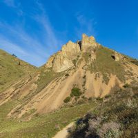
To be clear here, Chopper is the taller peak immediately uphill (west) of Wenatchee’s Castle Rock. The name is noted as such on the USGS maps of Wenatchee, but long-time locals might also know the peak as ‘The Thimble’. Regardless of what people call it, I call the eroded, unmaintained trail to its summit a stair-stepping grunt.
The warm-up to this taxing but worthwhile workout is the standard trail leading most of the way up Castle Rock. At the saddle a hundred vertical feet below the summit of Castle Rock, however, I turn left (away from Castle Rock) and attack the far larger mound of Chopper. Immediately the trail shifts from warm-up to hammer mode and for the next 25 minutes I climb the Stairway to Heaven trying to stay below the heart rate separating an aerobic workout from a heart attack.
At the top as my pulse slows and my vision returns, I take a few minutes to appreciate what my wife will not derive from an indoor workout – a 360-degree vista of the gold and green folds of our foothills to the west and the blue ribbon of the Columbia River snaking through the valley far below. Then it’s time for the next physical challenge: The Chopper Plunge. Going down this steep, slippery trail taxes balance and proprioception as effectively as the uphill taxes the ticker. This means calling this outing the Chopper Stair Stepper is an understatement. It deserves to be called the Chopper Twofer.
Castle Rock and Chopper Details
Access. Turn west off Western Avenue in Wenatchee, onto Castlerock Avenue. Drive uphill for 0.3 miles until the road ends in a small parking lot. If the lot is full, drive down the road 75 to 100 yards for curbside parking. Don’t clog the curbside near the end of the road -- this prevents emergency vehicles (think fire engines) from executing a U-turn.
Trip Instructions. Hike the trails upward toward the summit of Castle Rock (maps of the area are displayed at many trail intersections). In about a mile, reach the saddle between Castle Rock and Chopper. Turning right takes you to the summit of Castle Rock in 4 or 5 minutes. Turning left and heading west, meanwhile, has you climbing steeply for a half-mile to reach the summit of Chopper (2,450 feet). Whether you climb Castle Rock or Chopper, retrace your route on the descent.
Distance. 3 miles round trip to the top of Chopper. Elevation Gain: 1,450 vertical feet.
Difficulty. The final half-mile up Chopper is a steep, loose, unmaintained social trail, requiring advanced hiking skills and balance. Descending without slipping and sliding is trickier than ascending. Intermediate fitness is required to complete the route at a relaxed pace while advanced fitness is needed to race from the parking lot to the top in, say, 40 minutes.
Seasons. You can visit year-around, but the steep scramble up Chopper should not be undertaken in wet or snowy conditions.
Equipment. If your knees, ankles, or balance are at all shaky, bring trekking poles for the tricky descent. And if you’re visiting in winter when the ground is frozen, bring MicroSpikes for improved traction.
Allowed: Hiking, trail running, dogs on leash (scoop their poop).
Not Allowed: Motorized use, horses, camping, off-trail travel, hunting, nighttime use, campfires, littering.
Land Ownership. The Castle Rock Natural Area abutting the parking area was acquired by the Chelan-Douglas Land Trust in 2013. The property was later deeded to the City of Wenatchee, but the Land Trust maintains the trails and holds a conservation easement to the property that prevents future development. The higher lands protecting Castle Rock proper and Chopper as natural areas were acquired by the Land Trust in 2023 and are referred to as Castle Rock Ridge.
Gym Membership? If, like me, you use our foothills as an outdoor gym for physical or mental fitness, consider paying a ‘gym membership’ to the Land Trust for keeping these lands available to us all. Acquiring and maintaining these lands requires the support of people who use them.
Additional Resources. View a map of area. ( https://www.cdlandtrust.org/sites/default/files/2024-11/Castle%20Rock%20trails%20map%202024.pdf ). Additional details about area from the Land Trust’s website. ( https://www.cdlandtrust.org/what-we-do/land-conservation/wenatchee-foothills/castle-rock-ridge )
Andy Dappen is a retired magazine writer and the founder of the WenatcheeOutdoors.org website. He was also a Land Trust board member for 15 years. Join him in helping support the Land Trust’s many projects that enhance our regional quality of life.
Online Resource

Trail maps, directions, more info

40 Years of Conservation Success
