Sign Up For Our eNewsletter
Get the latest news, happenings & more from the Chelan-Douglas Land Trust.


Article in partnership with The Wenatchee World
by Andy Dappen
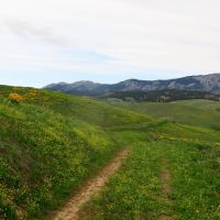
Most hikers would profess that the spring wildflower season is when the Cashmere Canyons Preserve is at its best. For me, however, it’s the fall when the trails, mood, and views at the preserve deliver my favorite flavors. For starters, the trails are far quieter this time of year. Also, after summer’s searing temperatures, sepia-colored vegetation, and pale skies, autumn’s cool air, golden grasses, and slanted sunshine are all such welcomed guests. Finally the misty, mountain views of Cashmere Mountain, Icicle Ridge, and the high peaks of the Enchantments cast a European feel to the landscape that transport me to autumn hikes I’ve enjoyed in the Alps. The air, colors, and scenery help catalyze this association, but the ethos of a place that allows the public to wander portions of a large private preserve also kindles these associations.
To explain this, Americans must understand that throughout most of Europe landowners cannot prohibit walkers from using trails, paths, river shores, or lake shores whose use predates the landowner’s purchase of a property. These easements all remain part of the common good as long as they are commonly used. Only through disuse are historic travel corridors closed and lost to the public. Because of this, a plethora of walking routes span the hills, mountains, water ways, and open lands of the European continent. This contributes to why walking in Europe -- for transportation, exercise or recreation -- is far more popular than in North America.
The miracle connected to the Cashmere Canyons Preserve is that the landowners of a sizable ranch willingly embraced this European ethos by allowing the public to use a number of old trails and grass-covered roads that circle some of the ranch’s scenic hills and ridges.
How this gift came about entailed not only community-minded landowners but the patient and collaborative efforts of the Chelan-Douglas Land Trust (CDLT). Working together over a period of many years, different strategies and opportunities were slowly but systematically explored. An access point for a trailhead with parking, a vault toilet and signage, was for years the sticking point. In 2018, however, the landowners acquired a new property along Nahahum Canyon Road that could accommodate a future trailhead. The purchased property abutted the existing ranch, allowing the visions of the landowners—for Cashmere to have a trail system that would bolster appreciation of the surrounding lands and boost the conservation ethos of the community – to grow legs.
In the coming years, the Land Trust applied for (and received) grants to help acquire a conservation easement on all 2100 acres of the ranch and to construct the trailhead. These grants along with donations from the landowners made it possible to open the area for hiking in 2021 – a goal some 16 years in the making!
That the ethos of providing travel corridors for the public good on private lands actually came together on this property sends me for a loop whenever I visit the preserve. Maybe that’s why I especially enjoy walking the route below, a route I call the Cashmere Canyons Loop to Loop.
Trip Details –
Access: From Highway 2/97 near Cashmere, drive three miles up Nahahum Canyon Road to the trailhead. The parking lot is on the west (left) side of the road. There’s a vault toilet and space for about 16 vehicles.
Trip Instructions: From the parking area, hike steeply up the Nahahum Trail to reach the Ridge Road (2 miles). Turn left and walk 0.3 miles to reach a fork in the road marking the start of Spring Canyon Loop – an undulating trail that will return you to this spot after a scenic 3 miles of walking. Take the left fork if you’re into clockwise travel, the right fork if counter-clockwise travel is your passion. Upon completion of the Spring Canyon Loop, follow the Ridge Road back to the Nahahum Trail (0.3 mile) and then another 0.8 miles in a northeasterly direction to another Y intersection marking the start of the Lower Loop. Again, take your pick as to whether to travel clockwise (left fork) or counterclockwise (right fork). Either choice brings you back to this very spot after 2.1 miles. Then it’s 0.8 miles back to the Nahahum Trail and 2 miles down the Nahahum Trail to return to the car.
Trip Stats: The roundtrip distance of completing both loops is 11 miles. The roundtrip distance of completing just the Spring Canyon Loop is 7.6 miles and 7.7 miles for completing just the Lower Loop. Elevation gain is 2,600 vertical feet if walking both loops or 2,000 vertical for completing just one loop.
Difficulty: Moderate to advanced.
Map: A map of the Cashmere Canyons Preserve can be found at the ‘Trails & Access Tab’ at www.cdlandtrust.org. (https://www.cdlandtrust.org/sites/default/files/2022-04/CashmereCanyonsMainMapJune2021_compressed.pdf)
Best Seasons: Spring and fall. Winter use is allowed but the trails are subject to intermittent closures to protect the mule deer.
Allowed: Hiking, running, and winter snowshoeing (all without dogs) are the only uses allowed.
Not Allowed: Dogs, mountain bikes, motorized vehicles, horseback riding, hunting, shooting, carrying of weapons, antler or shed collection, camping, littering, fires, fireworks, smoking, alcohol use, drone use, off-trail travel, and skiing are all prohibited.
Important: This preserve is a conservation area first with public access being a secondary goal. Continued recreational use of these private lands depends on visitors adhering to (and enforcing) these rules.
Land Ownership: The Cashmere Canyons Preserve is privately owned with a conservation easement to the property held by the Chelan Douglas Land Trust. A conservation easement is a purchase of a property’s future development rights so that natural lands and open areas can remain that way into perpetuity.
Upcoming Events: In October, CDLT will host many volunteer work parties. Volunteers will help restore local trails and plant native plants at Saddle Rock Natural Area and Horse Lake Reserve. Work parties are scheduled on weekday afternoons and weekends throughout the month. Whether you are a seasoned volunteer or participating for the first time, these events are a great way to get outside, give back, and connect with others. Sign up at cdlandtrust.org.
Andy Dappen is the founder of the WenatcheeOutdoors.org website and a former board member of the Chelan-Douglas Land Trust. He hopes people who frequent Land Trust properties will join the organization and support its work.
Forty for Forty. Recognizing the 40th Anniversary of the Chelan-Douglas Land Trust with 40 stories about places the CDLT has protected and kept open for public access.
Online Resource

Trail maps, directions, more info

40 Years of Conservation Success
