Sign Up For Our eNewsletter
Get the latest news, happenings & more from the Chelan-Douglas Land Trust.


Article from The Wenatchee World | March 15, 2025
Forty for Forty: Completing 'The Loop'
In the spring of 1990, the Chelan-Douglas Land Trust was at a low point. Operating solely on volunteer energy for five years, scoring only a few conservation ‘wins’ in that time, and contending with public officials, many of whom opposed our conservation goals, had some of our founders discouraged and burnt out. As the organization’s president at that time, I called a special meeting of the Board and invited Gordon Congdon Sr. and Bob Parlette to discuss an important idea.
The bike trail through the parks along the Wenatchee side of the Columbia River had been open for several years, but talk of a trail on the east side of the river to create a 10.5-mile loop was circulating in the community and creating interest. There was also opposition to the idea among those who thought such a trail would be expensive to build and not heavily used. Furthermore the trail would occupy a Department of Transportation easement and those opposing the trail thought a future riverside highway would make better use of that easement.
During our special meeting, Congdon and Parlette, both visionaries and both seeing the contribution such a trail would add to the regional quality of life, emphasized the need to rally the community and “get the damn thing built.”
The Land Trust Board agreed, but the issue was how to win the support of county commissioners and city governments on both sides of the river. In those days the Land Trust was viewed with some hostility and, mistakenly, seen as an organization trying to thwart development, remove properties from the tax rolls, and impinge on private-property rights.
At that meeting we decided the best strategy ahead was NOT for the Land Trust to lead the charge, but to form a separate non-profit organization that would be free of stigmas. The new organization, which became The Complete the Loop Coalition, would avoid being associated with the Land Trust, even though quite a number of people would be involved with both groups.
Over the next six years and over the course of hundreds of conversations and meetings with the public, city officials, county commissioners, and PUD representatives, enthusiasm and support for the idea grew. Funding from grants, city governments, private contributions, and corporate donations came together. And as as we now all know, the trail that was officially named the Apple Capital Recreation Loop Trail got built. It was mainly completed by 1994, but some of the final touches were added in 1996.
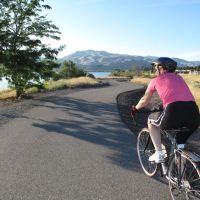
Today, walking some portion of ‘The Loop’ is a frequent outing for me. I need the exercise and the views over the rivers (both Columbia and Wenatchee) are gorgeous. On a clear day, views of the foothills and the high Cascades dressed in white can be spectacular. Wildlife on the river and along the trail adds to the experience. And on the east side of The Loop, the trail is quiet and feels a world away from the hustle of the nearby cities.
We are lucky the divide-and-conquer tactics formulated at that meeting back in 1990 worked. And we are especially lucky that people like Gordon Congdon Sr. and Bob Parlette (both deceased now) had the courage, and perseverance to bring their vision to life. So whether you walk it, run it, bike it, or skate it, be sure to treasure it — just a little different twist of fate might have seen that easement occupied by yet another highway.
Loop Trail Details
Generalities: The 10.5-mile-long Loop Trail is Wenatchee’s most famous walking and cycling trail. Along the western banks of Wenatchee’s riverfront, this paved trail traverses a series of riverside parks bordering the Columbia River. Once the trail crosses the Odabashian Bridge (Highway 97) on the north end of town, it follows the far wilder waterfront of East Wenatchee winding its way south before recrossing the Columbia River on the Pedestrian Bridge and returning to the starting point.
Two additional paved trails now connect to the Loop Trail. On the east side of the Odabashian Bridge, a paved spur follows the Columbia River 5.5 miles north to the Rocky Reach Dam. And on the east side of the Pedestrian Bridge, another paved spur travels 2.2 miles south along the Columbia to Hydro Park.
Uses: This is a popular non-motorized trail for walkers of all stripes from serious fitness fanatics, to parents with kids, to senior citizens with canes. Besides walkers, you’ll see joggers, bicyclists, in-line skaters, dog walkers and more.
Access: There are many access points to The Loop on both the west and east sides of the river. Use our schematic map to decide which access point is most convenient for you.
Length: Between The Loop and its two spurs, outings from one to 25 miles in length are all possible. On a bicycle, the complete 25 miles is easily ridden in several hours. Walkers and runners are more likely to enjoy covering this distance by starting at different access points and walking all segments of the trail in different chunks.
Other: The Chelan County PUD maintains much of the west side of the loop. Their website (www.chelanpud.org) has more information about The Loop and Hydro Park (click on the ‘Our Parks’ tab).
Upcoming Events: Join the Chelan-Douglas Land Trust and Colombia Valley Community Health for this year's Hike for Health Series, starting in March. On March 15, 2025 we will be offering a guided walk at Coyote Dunes on the Apple Capital Loop Trail starting at 9:00 a.m. For details and registration visit: https://www.cdlandtrust.org/outings-events/events/march-hike-health-caminata-por-la-salud-marzo
Eliot Scull is a retired ophthalmologist who was one of the founders of the Chelan-Douglas Land Trust as well as a long-time president of the organization.
Online Resource

Trail maps, directions, more info

40 Years of Conservation Success
